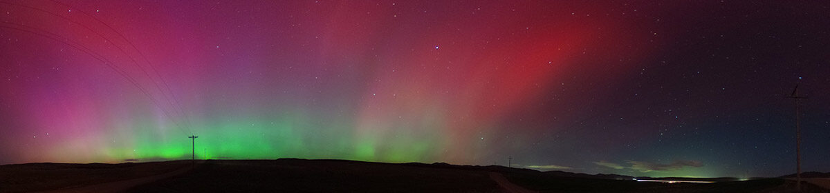
The 2002 Winter Olympics Countdown Clock is pictured at the TRAX Arena Station on July 9, 2017. The station is feet away from Block 85 on South Temple, which was a key downtown site during the 2002 Winter Olympics and is scheduled to play an expanded role in the 2034 Games.
Local news announced last week that The Church of Jesus Christ of Latter-day Saints is planning to close and demolish the church-owned Plaza Hotel on South Temple near its Temple Square in downtown Salt Lake City.
The church stated several reasons for the pending closure and demolition, but one of the initial uses for the site will be additional parking for public tours of the Salt Lake Temple when renovations are complete by April 2027. Temple open houses — which provide public access to a site that’s ordinarily limited to the certified faithful — are usually well attended and I foresee the church needing that additional parking during the open house.
When this item was discussed on Reddit, many, many people took the opportunity to complain about the church and rue the decision to add even more parking in a downtown that doesn’t lack for public parking.
Many were candid and admitted that the current hotel is dated and generally not regarded as an architectural gem (although Hoodline called it “iconic”), but they would prefer the faded building over parking. A subsequent blog entry from a site focused on Salt Lake development pointed out that the church’s initial intended use of the property for parking may run afoul of city code.
I certainly sympathize with the complaints, but I think temporarily building a parking lot could ultimately lead to _adding_ green space downtown. However, we must be open to possible uses of downtown properties and having a constructive relationship with the church if my idea is to become reality.
The basic situation is that Plaza Hotel is roughly one block east of another church-owned property called Block 85. Block 85 is currently dedicated entirely to parking, which would appear to do well when the Jazz or Mammoth are playing at the nearby Delta Center or if there’s a big convention at the Salt Palace across the street (IIRC, it was used as outdoor show space for the Outdoor Retailer convention in years past).
When those Games are over, Block 85 should be upgraded into a lasting landmark celebrating the Olympics as a park and public space.
Most past Olympics hosts have a park or other green space celebrating the Games and being one of the few cities around the world to have hosted such an event. It’s unusual that Salt Lake City wasn’t able to create such a space after the 2002 Games, but there might be an opportunity with the pending demolition of the Plaza Hotel.
The church has not stated what its long-term plans are for the hotel site. Perhaps the church could be persuaded to build a parking garage on the hotel site. I would certainly argue that failing to create a park space may be a missed opportunity for all involved.
If a parking garage is built on the former hotel site, there shouldn’t be a need for a staggeringly huge parking lot on Block 85. In that case, I would hope that the church, the Salt Lake City government and local Olympics organizers could implement a plan to turn Block 85 into an Olympic park.
Block 85 is centrally located and adjacent to TRAX light rail. It’s also close to many important attractions, including Temple Square, the Salt Palace Convention Center and Delta Center (which Jazz/Mammoth co-owner Ryan Smith is envisioning as the center of an expansive … and expensive … entertainment district).
While it may be somewhat satisfying to bellyache about the short-term plans for the Plaza Hotel site, I hope that the public can appeal to those in charge to collaborate and take a decisive leap into reshaping two large downtown properties to create a unique and unifying community space.
An iPad screenshot shows a heat map from Google Photos indicating where photos had been taken based on geotagging or Google determining identifiable landmarks.
With this year’s Independence Day celebrations fading into memory, I was thinking about the fact that I’ve had the opportunity to travel across great swaths of this wonderful and beautiful nation. In one sense, I’ve been everywhere (man) — from coast to coast to coast to coast. In another, I haven’t been to nearly enough destinations.
I’ve wanted to write about the map feature in the Google Photos app (Android and iOS) for quite some time, but it was hard for me to summarize why I feel this feature is so amazing. The Fourth of July celebrations brought this picture into focus as I realized that I’ve been able to visit so many different destinations, as specified in many of the songs about our nation.
The first song that came to mind was “This Land is Your Land” by Woody Guthrie. This song stands out strongly in my memory in part because we sang it every morning in kindergarten when I was living in Southern California.
A photo of the author in front of a pair of redwood trees at the Muir Woods National Monument in Mill Valley, Calif., on May 8, 2016.
For as encompassing as the song is, “This Land is Your Land” mentions only four specific destinations and they’re in the first verse — “From California to the New York island/From the redwood forest to the Gulf Stream waters.”
Of those four, admittedly broad locales, I realized that I’ve been able to either visit or live in all four over the course of my life. Unfortunately, the map feature in Google Photos doesn’t reflect this — my trips to New York and the coasts of Texas, Florida, Georgia and South Carolina all predate when we all carried cameras with us on a daily basis and where we could take endless numbers of photos without worrying about loading or developing film (so before the iPhone, basically).
Using the photos that are uploaded to the site/app, Google Photos generates a heat map based on the location data in the user’s photos plus whatever identifiable landmarks Google can identify in the images itself. The features is accessible under the search menu. It shows up as “Your map” (but it’s not available on the desktop version of the app).
A screenshot shows the Places map in Apple Photos.
I will note that Apple Photos also has the option of showing photos based on where they were taken, but I don’t find Apple’s solution as engaging or appealing as Google’s. Apple Photos shows thumbnails based on location. Zooming in will increase the number of thumbnails, but it seems clunky and inelegant compared to Google’s heat map.
The heat map evokes memories of past travels, family reunions and other adventures. I’m agog seeing some of the paths that I’ve taken over the past 39 years.
It evokes the spirit of roaming and rambling from Woody Guthrie’s song. There’s also some of the energy from the burgeoning lists of destinations called out in songs like “I’ve Been Everywhere” or “Living in America.”
The map displayed by Google Photos also reminds me of the map from “The Voyage of the Dawn Treader,” by C.S. Lewis. In that book from “The Chronicles of Narnia,” a magician gives the captain of the titular ship a map of the ship’s voyage to that point. The map was so detailed that when one looked closely with a magnifying lens, they could see accurate drawings of the actual place albeit at some distance. On the other hand, the map was incomplete in some areas because it could only depict where the ship had traveled.
The Google Photos map can feel like magic at times, even though it is simply a matter of technology and information (although Arthur C. Clarke did say something about technology and magic…). Zooming in on the map offers some joy as I can see the areas where I’ve been able to visit. Like the magician’s map from “Dawn Treader,” it can show documented locations in remarkable detail but be incomplete in areas lacking photos.
A screenshot from Google Photos shows a map indicating where photos were taken during a flight from Salt Lake City to San Diego in October 2016. Thumbnails of the photos from the trip are displayed on the right side of the iPad application.
When one zooms in far enough, one can sometimes see individual points along a trip, which can be an interesting way to relive a past journey. At other times, the data can be a bit of a muddled mess — good luck sorting through the 2,800 photos I’ve taken over the course of six years around the venue where I curl, the Utah Olympic Oval in Kearns. The Oval is my most-photographed location by far.
A screenshot shows a heat map from the Google Maps app showing the approximate location of 2,700+ photos taken in and around the Utah Olympic Oval in Kearns, Utah.
The heat map of the Utah Olympic Oval also exposes some inaccuracies with the location data. GPS can give a good approximation of where a photo was taken (or where your phone is at a given point), but it’s not 100% accurate all the time. Some of the photos that the map says were taken outside the building were very much taken _inside_ the building (the ice is usually a giveaway, particularly in the summer).
It’s amazing that over 27,000 of my photos have been tagged — it’s probably about 95% of the photos that I’ve ever taken in my life. The vast majority of photos have tags because I took them with a smartphone with GPS. That era essentially started for me in September 2013 with an iPhone 5 issued for work (I bought a Samsung Galaxy SII in April 2013 but it didn’t have a data plan).
For the earlier era where photos were taken with a film camera, a digital point-and-shoot, a “dumb phone” or a feature phone, I’ve had to go back and manually map where I took the photos. That process is inevitably incomplete — there are some places that I don’t remember exactly where I was or there are photos where it doesn’t make sense to tag (including photos of loved ones taken by others but I was not actually present for).
Before tonight, I didn’t know how many photos were tagged by Google based on its ability to identify landmarks. When I first discovered that Google was attempting to locate photos way back in 2017, the process could be hit-or-miss. For example, I had taken a photo of a train car during a 2009 trip through California. For some reason, Google thought the photo was taken in Kunming Shi, China. It’s northwest of Vietnam — and nearly 7,500 miles from the nearest Amtrak stop.
Just a bit off the mark. In 2017, Google Photos thought this photo of an Amtrak train car was taken in China — about 7,500 miles from where it was actually taken.
Since then, Google has appeared to get better as guessing where I might have been. It’s been interesting to take photos or videos during plane trips (when the phone is supposed to be in airplane mode) and to later see that Google had apparently located where they had been taken (again assuming that I wasn’t a dummy and I remembered to put the phone in airplane mode during the flight).
For example, here’s a screenshot of a photo I took of the Salton Sea. Google Photos was able to correctly identify the location.
A screenshot shows a photo taken in September 2021 from an airplane showing the Salton Sea and an estimated location by Google Photos.
Apparently, Google Photos has estimated locations for about 6,200 of my images. Interestingly, it doesn’t include some of the aerial photos of the St. George area that I thought Google was able to place. That must mean that I was an insensitive jerk and didn’t use airplane mode during that trip. Whoops.
By the way — It may seem creepy for Google to have so much location data and it can be. Unfortunately, it appears that Google Photos only has an option to remove the estimated location data. As Google notes, “If the location of a photo or video was automatically added by your camera, you can’t edit or remove the location.” In that case, it seems that the best option is to disable location data on the phone/camera _before_ taking the photo.
I don’t necessarily mind saving location data because I find it to be a useful set of information. I do try to be selective in the images that I share, but if I needed to be extra careful, I would need to take additional steps to ensure that people couldn’t find geodata (or identifiable landmarks) in the images.
While I find this data useful, it seems like it would be difficult for a stranger to really root through the information. Google Photos presents the location data in a heat map that someone needs to interact with to learn any additional context (such as dates). The map also doesn’t appear to be shareable.
Google has taken the additional step of turning off location sharing by default in some common ways of sharing information like shared albums or conversations (it can be turned on by the user and was apparently on prior to 2021).
I also know that the heat map is woefully incomplete — as I mentioned earlier, the map can only show places that I’ve taken photos of. I’ve visited or traveled through 42 states, but the heat map can’t show that because there simply aren’t many photos from my time living in the Southeast or my lengthy trips across the Sun Belt, Midwest or the Northeast (or visits to Canada and Mexico, for that matter).
The map can also exaggerate single trips across great distances. This can be seen with my single trip aboard the Empire Builder train across the Upper Midwest in 2009. It was memorable, but my only trip through North Dakota and Montana is depicted as a giant blue ribbon on the map.
The map is ultimately a fun look at where I’ve been. It is truly amazing that we have so much freedom to travel about the country. It’s a right that has sometimes been denied to Americans (and regrettably still is to some extent today). I certainly don’t wish to take this right for granted.
The map also indirectly shows places where I haven’t been. Even in areas where it looks like I’m well traveled, there are destinations that I haven’t yet been able to visit such as national parks in Utah.
I don’t know if I’ll get to some of these locales — such expeditions depend on time, money and planning. If I do, I’ll make sure that photos from those trips are added to my Google Photos map.
A screen capture showing Google’s Picasa desktop software running on a Windows 7 computer on Thursday, March 10, 2016.
After years of languishing behind projects like Google+ and Google Photos, Picasa is finally going to the great software and Web service cemetery beyond the clouds. Google announced last month that Picasa was being retired, and the end begins March 15 when the company stops support of the Picasa desktop app. Picasa’s online Web albums will be changing starting May 1.
I’m writing today so people may have the chance to download the Picasa’s free software for Windows and Mac before it’s taken offline. Although I started with Picasa’s Web service, the desktop software has become an invaluable way to quickly sort images and do some basic editing (although the editing tools are closer to Instagram than Photoshop). Although Google is seeking a single service that works on mobile and desktop, that solution isn’t ready today.
At first glance, Picasa is a tough sell as it was first developed when software companies were determining how to bridge software that resided on local computers with cloud services. Picasa was both a desktop app (that Google initially acquired) and an online photo service and it could be hard to explain the difference between the two to others. The two services even had different Web addresses — the app was available at picasa.google.com while the Web service was available at picasaweb.google.com.
A screenshot shows the desktop software at the top of this blog post. Readers may contrast that with a view of the Web albums below.
Here’s a look at the Picasa Web Albums service as viewed in Google Chrome on March 10, 2016.
Compared with modern applications and Web services, both versions of Picasa look a bit dated but they were still generally effective.
When it came to sharing photos online, Picasa Web Albums made things simple without the clutter of other photo-sharing services, like PhotoBucket. You could embed individual Picasa images on other sites or share slideshows of entire albums. These features are not currently available in Google Photos.
The biggest advantage of Google Photos is that it can store all of your photos at a usable size (Google+ Photos had a pretty small image size limit). I’ve found it extremely convenient for locating and sharing individual photos, but I’m less inclined to share whole albums. To be fair, I didn’t choose to share many albums with Picasa Web Albums, but I miss the ability to view other’s public photo profiles and share my own.
Ultimately, I’ll likely miss the desktop software most of all, especially when it came to processing screenshots. As someone whose personal computer is a MacBook, it’s easy to take cropped screenshots with the Command-Shift-4 keyboard shortcut. On a Windows PC, it’s initially easy to take the screenshot with the PrtScn key, but then you have to go to an image app like MS Paint, paste the screenshot into the image, crop it and then save it.
Picasa for Windows allowed users to skip a couple of steps. When Picasa was running, the PrtScn key captured the desktop directly to Picasa (alas, no secondary screens). With the image already saved, it was easy to go into Picasa, edit and crop the image and export it from a bitmap to a JPEG or PNG file.
The rest of the desktop app’s tools were straightforward. You couldn’t cut out or easily modify smaller elements of an image (something that had me running to Photoshop a couple times last year). The tools were useful for basic photo editing and caption information was saved in an IPTC format, which saved a lot of time for work. Users could also add text to an image, which saved me a lot of grief when I was working on my Christmas cards.
As much as I liked the desktop software, it could get a bit difficult to manage images, especially as it tried to cope with updates from other developers. For example, it was great that Picasa was able to read Apple’s iPhotos image database, but that advantage is practically wiped out when the image database splits up images by date (instead of albums or something more useful).
Ultimately, it makes sense for Google to let go of Picasa as the desktop app was last significantly updated more than four years ago. It will also reduce some of the confusion of Google’s image programs (which will still include Google Photos and the Snapseed mobile editing apps). I hope Google Photos will pick up some of the features of the Picasa services. Google Photos offers some incredible advantages, especially with facial and object recognition, but I think it has some ways to go before it can be a suitable replacement for Picasa.
Just a few changes to help make my site look a little more spiffy.
I’ve added a module to the right showing my latest blog posts. It seemed kinda silly to post elsewhere and leave this blog hanging. It’s not like I haven’t been writing, just not on this blog.
Hopefully that’ll change soon, but there’s a lot of other things I’ve got to work on. Stay classy.
Well, things don’t look too good right now on my webpage. Geocities has disabled my FTP access so I can’t up load any blogs with Fetch. So it looks like I’m out of luck for right now. I’ve been working on a sketch for a redesign, but it’s not going anywhere right now.
I’m also getting used to using Macromedia’s Dreamweaver 3.
So, it’s 10:18 a.m. EST and I’m staring at the computer screen. I’m thinking about anything except writing my story. Steve: What’s the current snowfall average to date?
Ryan: You want the average to today?
S: That’s what I’ve done before.
R: To today?
S: Well I’ve done it to the end of the month.
R: Oh, OK I can just add up the average snowfall from each month through February. [starts punching numbers in calculator]. It’s 150.
And it goes on like this for a few more minutes. sigh
Why can’t I get this page to refresh? I don’t even know why I working on this right now – I’ve got mounds of work to do and I’m slowing growing tired. Oh well. Still trying to get the beast to work.
My senior year at UC San Diego began yesterday. I am looking forward to one of the busiest times in my life. This site might be static for a little while as I concentrate on higher priorities. I will post another update soon.
Before I am buried under my workload, I have created a Sherlock plugin for UCSD’s search engine. Sherlock allows Apple Macintosh users with Mac OS 8.5 or above to search many different sites from the Internet. There has been talk about putting the plugin on UCSD computers. You can download Stuffit or BinHex archived versions of the plugin.
12 September 1999
It’s six in the morning and I’m updating my webpage. Am I crazy? You betcha.
9 September 1999
My index page will continue to be “black” throughout the weekend. On Monday, I am going to launch an action page containing the issues that I have a passion for — including free speech issues.
There is one additional article from the Freedom Forum concerning Kincaid v. Gibson. One quote from Mark Goodman, director of the SPLC, stood out in the article.
“This decision represents an almost 180-degree turn from the strong First Amendment protections that have traditionally been afforded public college student media. Make no mistake, if allowed to stand, the decision · will gut student journalism programs at some colleges and universities.”
Kincaid centered around Kentucky State University’s withdrawal of The Thoughbred student yearbook from circulation for reasons such as “lack of school colors” and poor quality. Full details of the case can be found at the SPLC’s Kincaid page.
Meanwhile at UCSD, I am still researching what may be a large gap in the state’s open meeting laws. Namely, laws that are supposed to ensure access to the public governing process simply don’t apply to the ten campuses of the University of California. You can see a summary of my research including the complete text of a state appeals court case that sets precidence for the university’s claims.
Now for some non-First Amendment content. Here’s my first set of short-attention span commentaries. I did hide some First Amendment stuff in there, but it’s all in good fun. (You, of course, realize that I’m going to disappear from the Internet when school starts. Enjoy it while it lasts.)
This case, Kincaid v. Gibson, marks the first time, an appeals court has used the U.S. Supreme Court’s 1988 decision in Hazelwood School District v. Kuhlmeieron (which allowed secondary schools to censor and restrict the speech of high school student media) to justify censorship of college media. Today’s decision directly affects states within the Sixth Circuit (Kentucky, Michigan, Ohio and Tennessee).
On a more upbeat note, FCC Chairman William E. Kennard announced that he intends to fully implement the proposal for the LPFM service. Kennard was speaking at the National Association of Broadcasters convention last week in Florida. The NAB has taken a position against the creation of LPFM. Write your congressman or senator in support of LPFM
3 August 1999
SALT LAKE CITY — Just spent two wonderful days in Utah with my family. We all gathered to take a family photo — even my aunt and uncle living in Tokyo. It was great to be back in the town where I was born. Now, I must prepare for the 11-hour drive back to Poway.
5 July 1999
Hey, hey. Here’s a badly needed update to my homepage. Check out some of the new stuff I added. By popular request, some pictures of my family will appear shortly. There are at least two more pieces that are almost ready for prime time.
Last quarter was my best ever. I had my best academic performance. I won two awards — second place in the SPJ contest and the Michael Sklar Award in the band.
9 June 1999
Go finals! I’ve got two tests on Thursday and Friday. Here’s hoping that they go well.
Ryan Olson – Award-winning Journalist!?! The San Diego Pro Chapter of the Society of Professional Journalists has posted the list of winners in their annual contest and I’m on it! I won’t know what I won until the banquet on June 10, but I’m psyched!
When I find out what I have won, I will post the story to the Guardian Stories section. BTW, there is a lot more stuff coming because I just started writing again. I’ll be back soon with reflections on 21 years of sobriety. – RTO
21 April 1999
Gosh, time flies when you’re having fun. It’s near the middle of the last quarter of my junior year and things are hoppin’! I just got back from the UCSD Pep Band‘s annual trip to UC Davis near Sacramento. The newspaper ran a photo of us on the front page. Check out the scan of the photos that I put on my UCSD space.
As with everything else, I am constantly looking at how to make things better. Instead of moving my site to Tripod as originally planned, I want to open a website dedicated to the music that I have been playing for 10 years. Be sure to look for it when I have a spare moment.
Anyhoo, studying awaits as I try to successfuly make my way through another quarter. Adios! – RTO
12 March 1999
The next generation of the Kronos One project is here. I’ve redesigned the main index page and getting ready to jump to Tripod. I’m (mostly) happy about the inside pages, so they shall remain mostly the same. If there are any errors, please e-mail me at rtolson@ucsd.edu
12/18/98
Created subdirectories for K1P pages.
Added news stories to the archieve in Guardian Stories.
9/12/98
Created In Focus to present commentaries and other articles.